Friday, November 23, 2007

Whirlwind Trip to Spain

By Aaron Webb

My wife and I have wanted to go to Europe longer than we have known each other. Rebecca has envisioned the backdrops of France, Greece, and Italy as her ultimate honeymoon since she was young. I always had in mind a visit to the castles of Germany and the British Isles. These all remained fantasies though. We stayed in the country for our honeymoon—having an extraordinary time in a few luxurious resorts of the redrock deserts in Utah—and have continued to dream of our eventual trip to Europe.

Through the years I have somehow picked up the notion that in order to go anywhere far away and truly enjoy yourself, you need to take an extended trip. I thought it would be foolish and costly to fly across the world to stay for only a few nights. That philosophy has led to the quiet death of more than one potential weekend of travel.

A few months ago, we set aside time for a vacation this October, the first one since our daughter was born. The months crawled by, closing in on the date as we surfed the net for vacation deals. We had a dream vacation in the works to go to Ireland, slowly building an idea of where we wanted to go, and what we wanted to do once there. Then, just a few months back, we made the decision that we needed to save more money; I was in the middle of a planned job change, and school and other expenses were still, as of yet, unknown. Ireland was again put on a back burner, and we began looking a little more local.

Time was moving on quickly. Katie was growing, babbling, crawling, and then walking. But we were so busy, exhausted, and discouraged by the hectic and busy turn that our lives had taken in the last year that we could find nowhere that spoke to us of rest and relaxation. Even the inspiration and the desire to sit down and plan an escape were gone. There was the baby to consider. There was work. Our schedules were ridiculous, and even on vacation it was looking like we would be working.

A few days before we were supposed to leave, my mom flew into North Carolina. She would stay and watch our little girl while we relaxed somewhere on our second honeymoon.

Only one problem: we still did not know where we were going.

Two days before our vacation started, we were just narrowing it down to a road trip somewhere along the Atlantic coast. Talk about failure to plan. My wife made the suggestion to drive down to Charleston, South Carolina, for the historic feel to the city, and the ghost tours of the old buildings. I liked the idea, so we rented a car and packed up. We did not have anything planned for lodging or food, or even specific sites to see, just a spot on a map. So we packed the tent and our sleeping bags, and everything else that we thought we might need on our improvised odyssey.

We were on the road, thirty minutes away from our home when my wife called a friend, who reminded us that the military had free flights for military families out of Charleston to Spain and Germany.

Spain.

Europe.

Rebecca got off of the phone, and we looked at each other, the unasked question very clear. I was already slowing down and getting ready to turn the car back for Jacksonville.

Back home, we rummaged in the garage until we found our passports—great place to keep legal documents—and ran back to the car as my bewildered mom laughed and held little Katie.

We did not know how we were going to swing it in the few days we had free, and we did not know whether the vacation would end up being more of a hassle than a relaxation. We did not even know if we would be able to get on the plane, for scheduling concerns, passport concerns, and a billion other little problems that seemed to rise into some unmountable wall. But we were determined to try.

We got to Charleston with enough time to drive to the beach and eat dinner at a nice little seafood joint next to the water, then drove back to the city and onto the Air Force base, where we went through the procedures required to be included on the military flight to Spain.

We were in a daze the entire waiting period, still unsure as to whether this was reality or a dream. It was the equivalent to a how a child would feel if all of a sudden he or she learned that Christmas would come twice this year. We kept talking about all of the things that we would do once we got there, the sites we would see, the food we would try, the dialects of Spanish that we would hear.

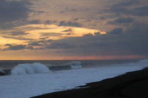
Our flight would take us to a place on the southwest coast of Spain, a town called Rota, which boasts an American Navy base. It was in the Andalucia area of Spain, the Mediterranean part of the country that boasts Moorish architecture, spicy food, and a warm climate. As we looked in our travel guide, we found plenty of castles, exotic Roman and Moorish ruins, and plenty of other mouth-watering attractions with which to sate some of our appetite.

Over and over we would look at each other in wonder.

Spain.

We were going to Spain.

Our flight was classified as Space Available, which means the military sticks you on a cargo jet, if they have room for you. Then you have to plan a return trip, again, if they have room. There were a dozen or so of us stuffed onto a plane full of armored vehicles destined for Iraq. The eight-hour flight on folding seats in a chilly aircraft was not the mahogany and suede image of luxury, but on a free flight you get what you pay for.

We stepped off of the plane into the surprisingly dry climate of south-western Spain, Andalucian ground. There was a moment of blockbuster-quality slowed time where we both simply looked to each other and smiled. We were in Europe.

Granted, we were still on an American military base, but we were there. It was already very late, so we spent the night in cheap military lodging and set off in the morning to rent another car and have my wife’s passport stamped. We had been given a ton of vague information on the correct procedure to make sure you are allowed back in the States, or are even able to successfully get a seat on a return flight. So we rushed around until the afternoon of that first day chasing stamps, papers, and signatures. As we went, we made hasty, adrenaline-fueled plans, like the huddle before the last down.

Then we were free. We had a little car—when I say little, I really mean little. Even their freight trucks are small. While I am sure that there are other reasons beside, we found out that Europeans drive tiny cars because anything bigger does not fit on their narrow streets. We drove down the Atlantic coast to an ancient town called Cádiz, the port where Cristopher Columbus set sail for the Americas on more than one occasion, and the oldest continually inhabited city in western Europe.

Cádiz was not at all the small village that I was expecting. There is a large, bustling downtown area where buses, toy cars, and throngs of people hurry from point A to point B throughout their day. But as we closed in on the historic area of town, we found archaic chapels, mansions, and fortresses, all crammed into the urban maze that is European city planning. There is a large castle out on a stretch of rocks, coral, and sand, accessible by a long stone causeway. People were off of the walkway, catching crabs and fish in the hundreds of tidal pools along the way. We found the castle gates locked, but were delighted to find the rocks an exotic playground in their own right. Anemones, sea urchins, shrimp, crabs of various size and color, and darting fish all inhabited these hidden basins of water among the treacherous footing of the jagged stone and broken coral. The incoming tide surged through tunnels in the coral, crashing up like mini geysers as we picked our way among the sharp crags and small pools.

We strolled through the streets until late that evening, enjoying the crowds, the old buildings and the atmosphere of the antique port. Finally, suffering from jetlag, tired and stressed out, we slept in our car while the gaditanos, as the residents of the old city are known, partied around us until the early hours of the morning.

The next morning, relaxing in bed until ten or eleven in the morning, we headed straight to Seville, the fourth largest metropolitan area in Spain, and an area with much historical and artistic value. If Cádiz was large, then Seville was immense. A bustling city if I have ever seen one; it reminded me of Buenos Aires, only more open. We were there on a Sunday, and still there were people and vehicles everywhere. We were searching for a local branch of our church there in Seville, and even after figuring out how to get there, it still took us another thirty minutes just to find a parking spot.

Let me warn you now how easy it is to get lost in the tight streets between 18th century—and older—buildings. On the map, you see where you are, and where you want to go. Then you get there and you find that you cannot just drive straight down the easiest route in order to reach your destination. Partly because the roads are rarely straight, and rarely last for more than two or three blocks before t-boning or making a lazy curve in some other direction. But even more confusing is the fact that all of these inner city roads are one-way. The streets were planned and constructed centuries before cars were around, and are extremely narrow. So we ended up driving around to the other side of the maze, parking half a mile from the church, and walking.

It was a nice walk, one that we had wanted to do anyway. It is a gorgeous city. Elaborately ornate buildings are everywhere downtown, and we had a lot of fun just holding hands as we walked and admired the architecture. We did not make it in time for our church meetings, so we sat on the steps and ate crackers instead, gazing at an old plaza with pretty fountains and lovely orange trees.

We took the opportunity then to finish the walk through the historical downtown and went to the royal palace and the cathedral. The palace was not open on Sunday, and you could not enter the cathedral, one of the largest in Europe, unless you were willing to pay, And we try not to spend money on Sunday. So we admired them from the outside. Looking at the cathedral gave my wife flashbacks of the Hunchback of Notre Dame.

On the way out of the city, we were trying to navigate back to Rota, our base of operations for the trip, without taking the toll road. But the non-toll roads are not as readily advertised or as easy to find, so we were having a hard time of it. After a half an hour or so of wandering up and down different routes, just as we were reaching the end of our patience with Spanish freeway planning, we stumbled into a suburb of Seville, the small town called Alcalá de Guadaira, complete with a sea serpent bridge, and a castle ruin.

Alcalá was an important city hundreds of years ago for the baked products that it sent to Seville everyday. A large percentage of Seville’s bread came from the smaller town. Even more, Alcalá was necessary to the area because of the castle. The town’s castle was one of the foremost defenses of the province.

Needless to say, we were thrilled about the castle. We spent the rest of the afternoon running along the crumbling walls of the ancient castle, which sits on a hill above the town. Alcalá has a long history; the Moors built the castle upon the ruins of a Roman settlement, whose baths have just been unearthed within the last decade.

The sun was sinking towards the horizon as we entered the castle walls, reading placards of information about the ancient structure. Boys were playing soccer in the courtyard, and the towers hovered over them, yellow and gray against a reddening sky. There was a feeling of peace there, despite the military purpose of the fortress. We climbed the walls and walked across their crumbling battlements.

Atop one of the towers, a solitary little oak, no more than a shrub really, grew out of the stone beside a worn gargoyle. It reminded both of us of the blarney stone of Ireland. So I snapped a photo while Rebecca lay on her belly and leaned over the edge of the tower to kiss the gargoyle’s head. Then we continued our exploration of the castle. Almost an entire roll of film later, the sunset was dimming in the west and we needed to leave. The castle was lit from the hillside below, bathing it in a yellow glow that shone like a beacon across the city.

Sadly, we drove away from Alcalá, intending once more to find a toll free route back to Rota. Though it took a few hours driving around on the confusing roads in the black of the Spanish night, we finally made our way back to Rota without having to pay a toll. Triumph.

There was a celebration going on in Rota when we pulled in, but I was tired, and figured that we would have other fiestas to attend, so we crashed that night at the naval lodging, exhausted and ready for a good night’s sleep. We awoke again too late for breakfast, a pattern we had set the first morning there in Spain, and begun to make plans for the morning. We wanted to go east towards Granada, Cordoba, and the White Towns. Every morning though we called in to check on outbound flights back to Charleston. This morning we were told that there would be no flights to Charleston for the rest of the week, and that the Rota airport was closing within a few days.

So we started asking about other destinations, and found that the only flight that would eventually put us back in Charleston, without pushing our luck, was leaving that afternoon. We had roughly four hours before we had to be back at the Rota airport, awaiting our flight to New Jersey, where we would spend the night and then fly down to Charleston.

Now I was kicking myself for having made sleep a priority over the party last night. You only live once, right? I think I am turning into a grumbling, creaking old man ahead of my time.

Our vacation had just been cut short by about four days. Bummed, we sat there for a while, trying to figure out what we could do in four hours. Should we stay in Rota? Should we try to find souvenirs for family members nearby? Too much to do, and so very little time.

The decision proved to be quite daring. We were going to drive out to the first of the White Towns, one called Medina Sidonia. It was just over an hour away according to the map. But we had up to this point not found much reason to trust the map, or the road signs (and the oft-time lack of road signs). Still, four hours. We could probably make it there and back in that time to catch our flight back to the States.

There was only one way to find out. This was an adventure after all, and I was determined to make up for missing out on the celebration the night before.

So we got in our rental and flew down the roads of Andalucia. Up until that point, I had been allowing traffic to race past me in their fanatic need to break the ridiculously low speed limits, but now I drove like I was not in Spain, but on the Autobahn of Germany.

The goal: to find and tour Medina in two hours.

The risk: get stupendously lost, late, and have to travel to Barcelona or somewhere else to pay for commercial tickets home.

The reward: see one more historical area of Spain in our three-day vacation.

The way was not nearly as hard as we were expecting, and with my genius wife navigating the tricky roads, and myself driving like a qualification for NASCAR, we got there in just over an hour. We found a strategic parking spot fairly quickly, and got out, cameras in hand, the paragons of tourists that we were, and began to soak in the sites of the beautiful town atop a gigantic hill.

Medina sits very high above the surrounding terrain, so much so that the rolling pastures and farmlands below have that hazy, graying quality as if you were atop a great mountain, or in a climbing airplane. The town is very obviously one of the White Towns; there were very few buildings of any other color. Roofs are still red tile and various other colors, but the whitewashed walls were the norm—I began to wonder if it was a city ordinance. Medina is clean, and very pleasing to the eye. Antique, and full of relaxed, smiling people who recline in the plazas outside of the tapas diners in the town square, enjoying their light meals and the conversations with old friends.

We climbed up to the towering chapel and paid for roaming rights. It was nothing in grandeur compared to the monolith cathedral of Seville, but possessed an elegance all its own. With bell towers that would have disappeared into the mist on a cloudy day, the chapel of Medina was an instant success on our risky venture to Medina. We sat in the tower, looking out over the broad valleys so far below, clinging to this last little bit of Spain that we would have to experience.

Finally it was time to go.

With a sad weight in our hearts, we descended from this little paradise and made our way back to the car, somewhere amid the narrow, maze-like streets of the town. It took a bit of back-tracking, but we found it. The hard part was finding our way out of the city, for the majority of perimeter roads dead-end instead of guiding you to the highway. Finally we stopped and asked a pleasant woman with a few children and she told us where to go.

Back on the highway, we turned our backs on Medina and raced once again like adrenaline junkies for Rota. I had bought a little bit of what in Argentina we would call chorizo gallego, or Spanish sausage, and some kind of old-world smelly cheese to eat with our crackers on the ride back. I kept it as a surprise from my wife until we were chasing the descending sun back towards Rota, and now we shared an authentic (minus the American crackers) Spanish treat.

Early on in our trip, we had hoped that the White Towns would provide our opportunity for souvenir shopping, and so we had not bought anything up to this point except for our meals. Medina, like the majority of Andalucian towns, is alive in the evening. Shops were not open during lunchtime, and we did not have the luxury of staying long enough for them to open later.

So, empty of tangible treasures, we found the airfield, twenty minutes later than we were supposed to report in, and turned in our rental car just in time to get our boarding passes and await our flight back home.

Sitting on the benches at the gate, we could just sit back and let our minds try to capture the fleeting images and memories of our frantic rush through Spain.

It was an amazing juxtaposition, our original wait in the air terminal, anxiously awaiting a flight to Spain, wondering if it were really going to happen. Now, we sat in the air terminal, wondering if it really had happened.

Certainly, it was different than any European vacation that I have imagined. We did not get to relax much, and we spent as much time worrying over flights and passports as we did taking in the sites of the country.

I am sure that some would say that we wasted our time. With the proper planning, and an ample amount of time, we could have truly basked in Spain’s luxurious historical sites and the exotic culture of spicy Andalucia. Truly, we still long for such a trip.

But if anyone ever asked if I would do it again had I the chance, I would tell them that I have rethought my earlier belief that it was too foolish and too costly to travel far for just a few nights. Andalucia, in three days, was one of those spontaneous adventures that I strongly feel a married couple needs every now and then.

We had a blast, and though sometimes I look back and seriously wonder if it was all in my head, I have the pictures to prove it. They were taken with a disposable camera, because we managed to misplace our digital, but some of them turned out much better than I expected, and I am including a good number of them with this article so that you can vicariously enjoy our whirlwind trip almost as much as we did.

Thursday, November 15, 2007

Big Donation Will Help Utah Fisheries

(Editor's note: This is a news release from Utah DWR.)


Big Donation Will Get Even Bigger

Fishing groups provide money for state’s Blue Ribbon waters

The largest donation ever given to the Division of Wildlife Resources by an angling group was received Nov. 14.

That’s when three anglers presented the agency with a $10,750 check from the Utah Stonefly Society and Cache Valley Anglers.

DWR biologists will use the money to improve fishing at waters in Utah that are part of the state’s Blue Ribbon Fisheries program. Right now, the Weber River in northern Utah is their first choice. The DWR will use the money to buy land that anglers can use to access the river. The money will also be used to make habitat better for trout.

“What’s really exciting is that these groups have actually provided more money than the original $10,750 donation,” says Walt Donaldson, Aquatic Section chief for the DWR. “Now that we have this money, other federal dollars can be used to ‘match’ the donation.”

Donaldson says the DWR should receive $12,000 to $30,000, depending on which federal program the donation qualifies for. That means the groups’ donation will result in the DWR receiving a total of $22,000 to $40,000 that it didn’t have before.

And all of that money will be used to improve fishing on the Weber River or at other Blue Ribbon waters in the state.

Dave Serdar of the Utah Stonefly Society says donations like this one are critical to making fishing even better in Utah. “It’s absolutely critical that the DWR receive funding beyond the dollars anglers provide when they buy a fishing license,” Serdar says. “Through the Federal Aid (matching dollars) program, any donation that’s given can grow to as much as three times the original amount.”

“I want to compliment these guys for raising this much money,” says Roger Wilson, cold water sport fisheries coordinator for the DWR. Wilson is referring to Serdar and Cary Asper of the Stonefly Society, Paul Dremann, chairman of Utah’s Blue Ribbon Fisheries Advisory Council, and all the members of the Stonefly Society and Cache Valley Anglers.

“We’ll put the money to good use,” Wilson says.

The Stonefly Society and Cache Valley Anglers raised the money through fly-tying and fly-fishing clinics they offered last spring.

More information about Utah’s Blue Ribbon waters is available on the Web at wildlife.utah.gov/blueribbon.

Monday, October 01, 2007

Brown Trout in Cottonwood Creek

Photos form this trip | Map of Joes Valley Area | Info on Joes Valley

Cottonwood Creek below Joes Valley Reservoir supports a good population of brown trout and fishing is good there right now. I fished the stream on Sept 29, during an early season winter-like storm, and had a great time. We caught fish, so many we lost count. Most were small but there were enough big ones to keep things interesting.

Cottonwood Creek is not well know and receives light fishing pressure, yet it has become one of our better streams. It flows along State Road 29, through Straight Canyon, between Joes Valley Reservoir and the small towns of Orangeville and Castle Dale, south of Price. It's about 140 miles from Salt Lake City.

It was raining when we headed down Hwy 6, heading toward Price. When we crested Soldier Summit and looked to the east the sky was only partly cloudy and we hoped the storm would miss the Joes Valley area. The mountains sometimes channel storms south, leaving that area dry.

Nope, we got hit hard by rain, sleet, snow and cold wind. The wind was strong and made fishing conditions difficult. Enough snow fell that it collected in some spots.

But the fish, they didn't seem to mind. The stream was low and clear and the fish were hungry. I had intended to cast streamers to them with my fly rod, but the strong wind made that next to impossible. Instead, we fished lures and jigs. Fish hit everything we tried. I started with a small Rapala and got strikes in virtually every hole. Most the fish were small and very aggressive. Even tiny fish would smack the lures.

We tied on jigs trying to get deeper, thinking large fish may be holding near the bottom in the bigger holes. My brother, Glen, tried a brown marabou jig and almost immediately hooked a large fish that gave him quite a fight. He was fishing from a big rock, up 4-5 feet above the water. The fish was heavy enough that he knew it would break off if he tried to horse it up the cliff face. There was no easy way for him to get off the rock but he finally jumped to the far side, hoping he could keep pressure on the fish. The strategy worked and he managed to land a fat brown that looked to be about 16 inches.

Glen hooked another large one that broke his line. I never managed to land anything bigger than 12 inches. One memorable fish charged at my jig, its mouth wide open, and startled me so much I jerked the hook away before it could hit.

The water was so clear, we could often see the fish strike our lures. Great fun.

Most streams that flow from reservoirs have clear water and are somewhat protected from flooding. That is somewhat true here but several side canyons can bring in heavy runoff at times.

SR 29 to the reservoir is plowed during the winter and Joes Valley is a popular ice fishing water. If offers splake and an assortment of trout.

The stream parallels the road. It is often a steep scramble from the road down to the stream. Large boulders have rolled into the canyon bottom, creating large pools in the stream. The boulders and brush make it difficult to walk along the stream in places. Still, the stream bank offers open areas where there is plenty of room to backcast while fly fishing.

All in all, this is a beautiful stream, well worth a visit.

Thursday, September 27, 2007

Sierra Club Highlights Utah Lands

The Sierra Club has released a new report, America's Wild Legacy, "which highlights fifty-two special lands and the Club's ongoing efforts to protect them." The 56-page report includes a section on Utah's Red Rock country.

Here are excerpts from the introduction:

Some of our nation’s most spectacular landscapes — places like the Arctic, the Everglades, Giant Sequoia National Monument, Utah’s Red Rock wilderness and the Tongass National Forest — are teetering at the edge and could be lost forever.

Illegal off-road vehicle abuse is scarring irreplaceable lands like Utah’s Red Rock wilderness.

The Sierra Club has long been involved in a battle to have more Utah public land classified as wilderenss and protected by Congress. That battle has been bitter and bloody at times, with those opposing the Sierra Club saying the vast majority of our public lands should be left open for energy development and multiple use, including ATV and off-road vehicle travel.

Read the Club's description of the report. Download the introduction. Download the complete report. It offers insights into spectacular country, regardless of what viewpoint you hold.

Saturday, September 22, 2007

Red Rock International Adventures

Some of my kids have an interest in this website and have decided to help me develop it. That's great because I haven't had time.

Interesting side note: this is happening as they go international. Our focus will be on the greater Utah area (Yellowstone to Grand Canyon), but now and then we'll sneak in an article about other areas. Here's the rundown:

Aaron, just back from Iraq, is living in North Carolina right now but intends to move to Utah later this year. He is an excellent writer and talented artist, so he will be a great help. He has already contributed a blog entry about extreme adventure in Al Anbar Province, and he's posted some of his photos.

Lil has decided she likes cruises; she and husband go somewhere every few months. Maybe I can talk her into sharing photos and writing up a report or two.

Dan has been scanning and posting photos for me, like the one above. I have a file cabinet full of slides, but I haven't had time to do anything with them. With Dan's help we're putting the best into our photo gallery. Dan will be trekking up a waterfall in Jamacia in November. His fiancée thinks they will be there on honeymoon. Dan should bring back interesting photos and a report.

Xanthe has been my model and fishing buddy - photos of her are all over this website. She is now going to college in Idaho. I don't know why she chose Idaho - I hear it gets mighty cold up there. But she is just outside Yellowstone and so we can expect reports from that area. She also helps with internet research and writing.

We've got great plans. Stay tuned because this website will soon be rockin'.

Tuesday, September 18, 2007

Tour of Duty: Al Anbar Province

By Aaron Webb

(See more of Aaron's photos from Iraq)

When you think of a grand adventure, what visions come to mind? Do you see slot canyons, underwater caves, and alpine slopes? What about the gear? Do you plan on stuffing your backpack with a two-man tent, climbing shoes, and insect repellant?

Or are you the person who has dreamed up images of wide, palm-crowded rivers in the deserts of a foreign country, where you patrol the wadis with rocket launchers and assault rifles, wearing armored vests and utilizing the most rugged night vision and communication equipment available?

Let me tell you about my latest journey to the ends of the earth.

I don’t even know where to start. I’m home from Iraq. It has been a few weeks now. Two and a half or so. In some ways it feels like I am slipping right back into normal life, like I have been gone to work over a long weekend or something. I don’t think I ever lost some of my rhythms upon leaving the states in the first place. Does that mean that I failed to engage the combat mindset? I am not sure.

Things are looking good. My faithful wife loves me. My nine month old daughter – she was two months old when I left for Iraq – didn’t seem to necessarily remember me, but she sure warmed back up to me remarkably fast. I have been offered a tantalizing job, writing for, and designing graphics for, redrockadventure.com, an opportunity that I am taking up with pleasure. It is a family-run business. One more way to remain close to those who I most care about. I am active in my church, and people seem not to have forgotten who I am. I am going back to school; I wonder if I will be the only twenty-seven year old freshman in the graphic arts program.

Other things are harder to gauge. I am adjusting well, but there are still hitches. I am ridiculously wary of the potholes on the roads as I drive. I hear machinegun fire on the Marine Corps ranges here at Camp Lejeune, North Carolina, and my ears perk up and I automatically start trying to determine distance, direction, and possible caliber of the weapons.

I anger a lot quicker than I used to. I am not nearly as patient and easy-going as a few years ago. Maybe that would have come anyway with growing up and taking on the responsibilities of an adult. I used to fancy myself Peter Pan, the boy who would never grow up. Flying would have been cool too. I have always been a free spirit of sorts, a happy, carefree guy who was always playing games, reading books, exploring Anasazi ruins, or catching snakes.

In fact, life has always been just one large adventure to me, a quest for something larger than myself. During tough times, I have even disciplined myself to think of it as a game, a challenge. That is one of the reasons I like that Italian film from the late nineties, Life is Beautiful. Sometimes it works. Sometimes it doesn’t.

The desire for exploration, for adventure, for a noble quest, has always been a driving factor in who I am. It is one of the reasons I love trekking through Grand Gulch with a backpack and a camera, or rafting down the Colorado, or climbing the spires of Zion National Park. It is one of the reasons that I went to South America to preach to the people for two years, learning a foreign language and foreign customs. It is also one of the reasons I enlisted into the United States Marine Corps infantry.

Iraq was certainly adventurous, and at times, a pure adrenaline rush. Just off of the plane in Kuwait, we were gearing up and loading ammunition into magazines, checking gear, and preparing to touch down in an unstable country with a fledgling government. A familiar military proverb – hurry up and wait – describes quite accurately how you slide into a seven month trip to this place of violence. We hit the ground running, alert, pumped up, ready for the worst that they could throw at us.

And we waited.

Three weeks passed. Finally we got a mission. And from that point on, until near the last two months of our deployment, we just kept getting missions, one after another. We ran clearing ops in three of the most volatile cities of the Al Anbar province, Ramadi, Fallujah, and Habbaniyah.

We ran some pretty spine-tingling operations, a few of which made the nightly news. We were working in an area where other, more stationary units were taking dozens of KIA during their deployments. We had our fair share of casualties, some of them very serious. I myself was the casualty of a roadside IED back in March. It was not too serious, but certainly startling. There were three other Marines with me at the time, and all four of us came closer than we would have desired to the flying slag and shrapnel of shredded vehicle armor and equipment. But we suffered only six fallen brothers in our battalion. All of them were courageously committed men who had earned the respect and admiration of the Marines they worked and fought with.

I suppose that there is still a layer of reality amid all of the games and challenges of turning life into an adventure. There is still responsibility. There is still emotion, both joyous and tragic. There is consequence. There is living with the choices you have made.

When I think of memorable experiences now, I will include other things to the standard list of bouldering, scorpion-catching, and stargazing. The rate at which my heart thundered in my ears as I kicked in doors and cleared rooms immediately after being hit by an IED on the roads outside of Habbaniyah definitely rivaled any high I have ever felt while preparing to leap into the dark waters of Lake Powell from a protruding sandstone rock face.

It was a unique thrill to poke around in the bushes at the edge of the Euphrates River, looking for camel spiders, cobras and saw-scaled vipers instead of bull snakes and diamondback rattlers.

The age and history of ancient Mesopotamia were tangible enough to be felt in my bones, and thick enough to be breathed in and tasted as I looked over the vast, desolate stretches of dust and sand outside of the frantic noise of the cities. It was not unlike the heavy sense of reverence that I feel upon sitting quietly and gazing upon the abandoned cliff-dwellings of the original Southwest inhabitants.

Racing up walls, roofs, riverbanks, and hills in over eighty pounds of armor, comm. gear, weaponry, and water, while not my favorite pastime, was still a personal challenge of endurance and reckless daring. Worthy of any of my twenty-mile day hikes back home.

I was reminded of my missionary days in Argentina as I went through the neighborhoods of Ramadi, Fallujah, and Habbaniyah, meeting the people, playing with the kids, trying to learn their language and customs. It was easy to see some good coming of an otherwise violently unpleasant situation, as Marines handed out school and medical supplies to eager children, as families finally dared to emerge from their homes because we had set up secure areas where they knew that insurgent activity would be sorely impeded, where they could live, and work, and play in peace. People would beg us not to go once we were done with an op.

I think that I will learn from and grow from the undesirable memories and lessons that I have from Iraq too. The tedious hours doing busy work while the rest of my squad is out on a recon patrol. The grudging patience with, and painful obedience to incomprehensible, and sometimes inane commands.

The horrible feeling of helplessness as I watch a combat surgeon operate on a man whose lungs are gunshot and rapidly filling with blood.

And I don’t think that I am ever going to forget the stench of charred human flesh. I am not going to get over the hollow in my soul that was there as I cleaned up the armor and weaponry that a fellow Marine had been using when he was killed.

There was still more to drag me down to stark reality once I came home as well. The weight in the pit of my stomach as I attended the memorial service of one of the guys that I was just joking around with in Fallujah. The convulsing sobs of another’s wife and children as the Chaplain talks of heroic deeds and noble sacrifice.

So, looking into my own soul, I begin to preach. Peter Pan, life is a challenge. A game. You know what you have to do. Don’t sweat the small stuff. Don’t panic when you can’t control the world around you. Don’t lose sight of the joy and the wisdom that later come from living a good life, even if existence is sometimes harsh.

So with all of those sins of commission lurking out there, what kinds of things should a person do? Go on a quest. Go climb a mountain. Kayak down a stretch of whitewater. Earn a degree. Teach kids in Peru how to speak English. Tackle one of your fears or weaknesses. Turn it into a strength.

Whatever it is, go courageously, and commit yourself to a cause, an exploration. And enjoy life.

I think that there is some solace to be had in the idea, to me anyway, that my fallen brothers didn’t go sitting down, doing nothing. They were actively engaged in helping their brothers in arms win the fight. Maybe all of them were on their own quests for adventure, for meaningful, life-inspiring experiences. There are some of us who knew them who have set aside a place in our hearts for honor, for mourning, for memories. I would hope that their sacrifices would have positive, life-inspiring effects on those who will still remember them even after the war in Iraq is over with and set aside for whatever takes its place.

Saturday, August 25, 2007

Guatemala Multi-Adventure Trek

Here's my daughter's account of her trip
See more photos from this trip


Monterrico BeachIt’s my daughter’s fault that I’m relaxing on a beach here in Monterrico, Guatemala, reminiscing about a fun trip where we mountain biked technical singletrack, explored an ancient Mayan ruin, kayaked across one of the most beautiful lakes in the world and climbed an active volcano searching for flowing lava.

Fresh out of high school, excited to go to college, Xanthe decided to spend part of the summer doing volunteer work at an orphanage in a developing nation. “Right,” I said to myself, not taking her seriously. But a few months later, when she had $1,000 in the bank, I decided she was serious and so I started to learn about Guatemala.

A friend works for a non-profit organization down there and she set up the volunteer stint. I wanted to let Xanthe see some of the sights and so I started doing Internet research about possible destinations. I soon discovered Guatemala does not offer posh, trendy resorts. Rather, it has many great albeit little-known wonders that appealed to my sense of adventure. Not wanting my little blond girl to wander around down there all alone, I happily volunteered to tour with her. (She was still on her own at the orphanage.)

I discovered that Guatemala is best known for its Mayan ruins (including Tikal and other famous sites). The country also boasts majestic volcanoes (three of which are active). Another well-known attraction is Lake Atitlan (which locals proudly describe as the most beautiful lake in the world). Atitlan is indeed beautiful, surrounded to towering, heavily forested volcanoes that climb almost straight up from the shoreline. Atitlan has become a refuge for displaced Europeans and Americans because it is beautiful, the weather is perfect (around 75F most days of the year), and the cost of living is low.

Guatemalan Mountain Bike
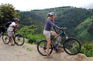
Lesser-known attractions include the country’s vast jungle/rain forest region, its wide rivers (including scenic waterfalls and some whitewater), and a long stretch of Pacific coast beach that is beautiful but almost deserted.

It soon became obvious that we could never see all interesting attractions in one visit. We decided to focus on the western side (since that is where the orphanage is located).

Usually when I travel I like a flexible schedule so I can wander a bit, adjusting to circumstance and my fickle whims. Not this time. Since I don’t know Spanish, and didn’t know the country, I elected to take the fat tourist approach and had a booking agency arrange a customized, fully-guided excursion. I told the people at enjoyguatemala.com what I wanted to do and they arranged transportation, hotels and guides.

Our trip unfolded exactly as planned and we had a very enjoyable time. Our guides were excellent (personable and knowledgeable about their sports). They kept us out of trouble and made sure we had fun.

Mayan Women Weaving
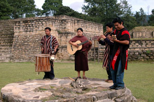
We began by exploring Iximche, a small complex of post-classic Mayan ruins. I learned that indigenous people consider these sites to be sacred. Some come there to burn candles and perform religious ceremonies. While we were there a small group assembled on one ancient structure and played traditional music, some using traditional instruments. The music was beautiful and the performers, in brightly colored costumes, created a memorable scene.

Next we biked down a mountain above Lake Atitlan. We started out on a dirt road, riding past cultivated fields and a small village. The countryside is beautiful and that part of the ride was pleasant. We stopped briefly at a lean-to where several women were working, hand weaving cloth for rugs and clothing items. With the women’s permission, I took several photos. I understand it is customary is to offer payment when you photograph natives; I did so and the women looked grateful.

Mayan Women Weaving
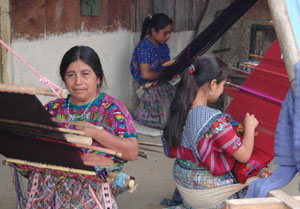
We continued our trek and soon turned off onto a rougher road, which crossed a stream several times. Ah, a little excitement. The road gave way to rocky singletrack, which plunged over cut banks where it crossed the stream. That part of the trail was technical enough that I had to get off and walk my bike over some spots.

I’m from Utah (USA), and we Utahns think we invented mountain biking. I’m not a great rider but I enjoy the sport and I’ve ridded with guides over some highly touted trails. That Guatemalan route was pretty good. And our guide really was excellent. He put us on good quality bikes and provided helmets and riding gloves. He was very enthusiastic about biking. Put him in Moab and he could work for any of the guide services there.

I learned that mountain biking is starting to catch on as a sport in Guatemala. Natives ride bikes everywhere, as a practical matter, but now some people are riding for sport, and blazing new trails through the volcanic mountains. The country has real potential for serious biking.

Lake Atitlan
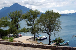
To end our ride we coasted down a paved road through the village of Panajachel, to the shoreline of Lake Atitlan. We ate lunch there and visited the open-air market. My sales resistance was low and I bought more than I intended. It is hard to walk away from the persistent little children and sad-faced old ladies.

Next we kayaked partway around the lake - paddling until we were good and tired. The villages around the lakeshore are very picturesque - picture postcard views in every direction. Xanthe couldn’t resist jumping into the clear water, which was cool but not cold.

I understand the lake offers good bass fishing, but I didn’t have time to try.

The next morning we meet our guide early and headed out to climb Pacaya Volcano. Hikes are possible on several Guatemalan volcanoes; some routes are quite challenging and a couple routes require multi-day backpacks. Pacaya is not one of the difficult ones. You can drive most of the way up the mountain and it is easy hiking the rest of the way if you stay on the well-established trail.

Pacaya is attractive because it is alive and unpredictable. During the past few months it has been erupting, slowly, with a continual small lava flow. Before that it threw a violent fit and shot ash out over Guatemala City, 18 miles away. The lava flow changes from day to day. Sometimes you can see the flow. Our guide hoped to get us up close enough that he could poke a stick into it. He had us hike a faint trail along the rim, searching for the lava.

We could hear it hiss and pop, but a cloud had settled onto the mountain and the mist made it impossible to see very far. It also made it dangerous to descend off the steep rim. We tried hard to find the flow, but gave up when the clouds thickened around us.

We hiked out onto new lava - which had completely filled up a valley during a large eruption last April. In spots you could feel heat coming up through the rocks. In one spot our guide shoved a stick down into the rocks and it instantly started on fire. Lava was close, right under us, but we couldn’t see it.

Pacaya is lush, like a manicured garden. Short grass, towering tress and flowers everywhere. It was beautiful in the midst.

To complete our tour we spent a night at a resort on the beach at Monterrico. The beach there is very nice, with clean black volcanic sand stretching for miles. The waves are strong and there can be strong riptides. That makes it tickly to swim, body surf or surf. But it also makes it exciting.

Small resorts and private residences sit just off the beach, along the scenic shoreline. But I was surprised because the beach was almost deserted. Even on Sunday there were only scattered groups here and there. And the beachgoers were all Guatemalans, as near as I could tell. Spanish was the only language I heard.

I gathered that the other people at our resort were young professionals with their families, taking a weekend break. The area has the potential to become a popular tourist spot, but the infrastructure (access roads, in particular) would need significant improvements.

I understand there is a small but growing local surfing community, although I did not see a single surfer.

The Guatemalan coast offers great deep-sea fishing, particularly for billfish, but I didn’t have time to try it.

It was a great trip. Now I’m anxious to go back. I think I’ll need to make several trips. I’ll be back, soon, exploring the classic Mayan ruins. I also want to boat into the jungle from the country’s small Caribbean coast. I’ve been told that Guatemala’s Caribbean coast provides easy access to the famous diving and fishing areas off Belize - that access is easier and less expensive coming from Guatemala than from Belize.

I’d also like to go deep sea fishing on the Pacific side.

Adventuring in Guatemala is affordable - I was pleasantly surprised at how cheap it is to fly to the country, stay in nice hotels and hire guides. Guatemala is one of those developing destinations not yet overrun by tourists, where you can enjoy great adventure at an affordable price.

But the country does have its problems. Traveler safety is an issue. When we read the US State Department synopsis on Guatemala we were concerned because it says there have been aggressive, violent attacks. That’s one reason I elected to go with guides rather than attempt a do-it-yourself adventure. But we had no problems and never felt threatened in any way. We took measures to minimize risk, and found the people to be friendly and hospitable.

Guatemala is a developing country. As you travel you see poverty. Many roads are inadequate and driving can be hectic. Many towns are congested and some areas look dirty and run down.

The country has an efficient bus system - busses go everywhere and it is very inexpensive to ride them. They are affectionately known as “chicken buses.” They are always crowded, with some people carrying produce and/or chickens and other farm animals. I would not recommend riding the chicken buses unless you speak Spanish fluently and take the time to learn about the culture and bus routes.

If you cruise to Jamaica or fly into fly into Puerto Vallarta you have a sanitized experience. Everything is beautiful. Third World? What Third World?

Now I enjoy a firm mattress, clean sheets and a nice steak. I don’t want to plunge headlong into trouble. But I enjoy meeting real people in real communities, muddy roads notwithstanding. I prefer to avoid sanitized resorts.

If you are really interested in seeing the country and meeting its people, consider volunteering at an orphanage. That was the highlight for my daughter.

Details:

Map of Guatemala

I booked through enjoyguatemala.com and they were excellent.

I enjoyed these tours:
Lake Atitlan Multiadventure
Pacaya Volcano Hike

Most major US airlines fly into Guatemala City
I flew Delta from Salt Lake City (SLC) to LAX to Guatemala (GUA)

Most tourists say in Antigua, an interesting colonial city. It offers several quality hotels geared for American and European tourists, plus a large central marketplace where you can buy anything - literally. Prices are good. Most tours leave from Antigua hotels. If you don’t book ahead of time, you can always find tours once you arrive in Antigua. Just walk through the market and you’ll see a number of companies.

I stayed at the Real Plaza Hotel in Antigua, Hotel Utz-Tzaba in Monterrico and Hotel Stofella in Guatemala City. All were mid-priced, comfortable and clean.

Tuesday, August 21, 2007

State Auction Will Sell Rec Property

The Utah Trust Lands office provided the info below. (Trust Lands manages school trust property, and occasionally sells off parcels to raise money.)

Dear Prospective Trust Lands Buyer:

The Trust Lands Administration will offer over 20 properties for sale at public auction on Friday, October 12, 2007, at 10:00 a.m. The auction will be held at the Little America Hotel in Salt Lake City. Some properties are suitable for industrial/ commercial uses or residential development. Others are ideally located for individual home sites, agricultural uses, and recreational uses. The following is a brief summary of the lands that will be offered:

Beaver County:
The North Creek property consists of 52.22 acres and is located approximately 5 miles northeast of Beaver and 3.5 miles southeast of Manderfield. The property is zoned for agriculture and offers privacy, solitude, clean mountain air, great views, and country atmosphere. The Fishlake National Forest boundary is only 2 miles away. The area offers many good recreational opportunities, including hunting, fishing, hiking, and site-seeing.

Box Elder County:
The Promontory North parcel consists of 714.38 acres and is located near the eastern edge of the Great Salt Lake on the west side of the Promontory Peninsula, approximately 9 miles west of the Golden Spike National Historic Site. The property has historically been used for seasonal cattle grazing.

Piute County:
Four parcels located on the northwest side of Otter Creek Reservoir, approximately 8 miles north of Antimony and 1 mile south of Angle, will be offered. The Otter Creek parcels offer excellent recreational opportunities, including fishing and boating, as well as easy access to Otter Creek State Park on the south end of the reservoir. Two of the parcels consist of 80 acres each and have some frontage on the reservoir when it is full. The other two parcels consist of slightly less than 40 acres each. The parcels will be offered separately.

San Juan County:
Eight Montezuma Creek parcels will be offered. The parcels range in size from 0.84 to 3.69 acres and are located in the city of Montezuma Creek on the Navajo Nation Reservation. The properties are in a developed area and are zoned for commercial use. Water, power, and sewer are available to each property. Each parcel will be offered separately.

Located in a remote area approximately 10 miles north of Monticello and 35 miles south of Moab, the Photograph Gap property is situated on the road leading to the spectacular Canyonlands National Park. This property consists of 180 acres. Good agricultural opportunity exists, along with recreational and residential opportunities.

Utah County:
Three Lake Shore properties, located about 5 miles west of Spanish Fork, are ideal for agricultural and residential uses. Parcels 1 and 2 each consist of 50 acres, and Parcel 3 consists of 120 acres. Two of the properties are currently being cultivated. The third parcel is horse property. Water rights are included. Each parcel will be offered separately. State financing is not available for these properties.

Washington County:
Located in a country club subdivision 5 miles southwest of St. George, the Tonaquint – Montezuma at Bloomington parcel sits in a small canyon. The site is exceptionally scenic and quiet, due to its canyon location and minimal exposure to roadway traffic. Large single family homes and the Bloomington Country Club and Golf Course are nearby. This 15.20 acre parcel is currently zoned as open space. A zoning change and other municipal approvals will need to be obtained prior to any development.

The Shoal Creek property is located approximately 2.5 miles west of Enterprise. This 10 acre parcel is bordered on all sides by private land. Some recreational opportunity exists. The parcel is zoned Open Space Transitional.

Wayne County:
Two Hanksville properties, just outside city limits, are suitable for various uses, including commercial and residential development. This property lies south of the town of Hanksville and offers excellent recreational opportunities, with easy access to Glen Canyon National Recreation Area and Lake Powell which are within an hour’s drive. Parcel A contains 80 acres, and Parcel B contains 160 acres.

State financing is available on most properties being offered. If you would like further information about any of the above properties, the auction process or financing options, please feel free to call me toll-free at (877) 526-3725 [877-LANDSALE], or visit us on the Web at www.trustlands.com.

Thursday, August 16, 2007

Another Monster Catfish Caught At Huntington North Reservoir

This is from a DWR news release:

Reservoir is yielding big catfish

HUNTINGTON — Price resident Calvin Grogan landed a lake-record catfish at Huntington North Reservoir on Aug. 8. The channel catfish weighed 27 pounds and measured 36 inches.

Grogan caught the fish at 10:20 p.m. that evening. Huntington North Reservoir is two miles north of the town of Huntington in east-central Utah.

Grogan was fishing from the bank near the boat dock that evening. He baited his size-2 treble hook with raw chicken meat and liver, and cast it into the water. Once he hooked the monster fish, it took him 20 minutes to land it.

This latest catch breaks a record at the lake that was established just three weeks ago by Clifton Elliot of Price. Elliot landed a 25-pound, 34-inch catfish on July 26.

This latest catch still falls short of the state record channel cat. It was caught in 1978 at Utah Lake. That fish tipped the scale at 32.5 pounds and measured 39.75 inches.

Tuesday, August 07, 2007

Utah’s Best Waterfalls

I found time today to upload some of my better waterfall photos. You can see them here.

This new waterfall photo gallery doesn’t include falls that are found in national parks or other areas. To see those photos look at my Zion Park waterfalls, Grand Canyon Havasu Falls, and Calf Creek Falls albums.

And I’ve tweaked my Google map showing waterfall locations.

I still have photos to upload, but I’ve run out of time.

Tomorrow I leave on a trek where I’ll be climbing volcanoes and exploring ancient ruins. Now, we have some of those things in southern Utah but for this trip I’m going to Guatemala where I’ll climb the active Mount Pacaya volcano and check out some Mayan ruins.

My daughter persuaded me to go on this trip. She has been down there for a few weeks, doing volunteer work at an orphanage. I wanted to let her see some of the sights, but didn’t want a little blond girl wandering around Guatemala by herself. Should be a fun adventure.

Does it fit under Red Rock? Sure, I’ll give a report on the trip.

Friday, August 03, 2007

Get Ready For Archery Deer Hunt, Turkeys, Chukars, Pheasants

DWR has released an Archery Deer Hunt forecast by region, saying the number of young bucks is up this year.

DWR includes tips for a safe archery hunt.

DWR is proposing major changes in turkey hunting, and has scheduled youth pheasant and cuckar hunts.

These are excellent, in-depth articles. Hunters interested in these species should read them.

Thursday, August 02, 2007

Google Maps Show Locations of Waterfalls

I've been way too busy lately, but have still found time to make a few website improvements. I've been implementing Google Maps on the site, and using them to provide an alternate navigation method.

I never actually finish anything, but my waterfalls section shows the concept. Note that when you click on one of the markers it opens a small window with a title, link and thumbnail. That gives you some info to use as you judge whether you want to click further to an inside page.

I plan to use this kind of scheme throughout the website, if I can find time to develop it. Fishing sections, in particular, will be enhanced when people can see where waters are, and see a photo of the waters, before clicking.

I'm interested in comments - what do you think about this approach.

- Dave

Saturday, July 14, 2007

Echo and Kanarra Creek Adventure Hikes in the Zion Area

This is one of the hottest, driest summers on record and daytime temperatures are pushing above 100 F most days in Zion National Park, but there are still plenty of great hiking opportunities.

Summer is the time to do water hikes in Zion. The most famous such hike is the Narrows - perhaps the most popular canyon hike in the world. You just head right up the Virgin River, wading and swimming in spots. It is great fun.

There are plenty of other similar hikes in that area, including the Subway. Some of these hikes are "technical," meaning you need to rappel and use other specialized techniques to get through the canyons. Permits are required to do the technical canyons.

Last weekend I lead a group on two such hikes and we had a great trip. Our primary goal was to do Echo Canyon, which is technical and requires a permit. Such permits go fast. Some can be reserved in advance using the Internet and some are held back and given out on a first-come, first-served basis beginning the day before you want to hike. We were not able to score a permit in advance and so we headed down hoping to get a permit for the next day.

You can get permits at the backcountry desk at the Visitor Center in Zion Canyon, or at the Kolob Canyons Visitor Center. I live in the Salt Lake area and so the Kolob VC is closer.


We left on a Friday morning and headed straight to the VC to see what permits we could get. I had several canyons in mind, hoping to get Echo but thinking we were prepared to do whatever canyon we could get. Luckily, Echo was available.

After getting the permits we had plenty of time to do an afternoon hike. We choose Kanarra Creek because it is close to the Kolob VC, because permits are not required there, and because I had heard it is a fun, very scenic, water hike that can be completed in a few hours.

Kanarra Creek (we have excellent photos from this hike)
Kanarra is beautiful and turned out to be more fun than I expected. From the tiny town of Kanarraville, you head east on 100 North and just follow a rough dirt road until it ends at the creek. Then you simply hike up the canyon. You are in and out of the water, which is clear and cool on a hot summer day. The canyon slots up and so it is shady, but you do have some sun exposure on the lower end.

To get up Kanarra you have to climb over two waterfalls. Logs have been placed against the cliff, and ropes extended along the logs, so you just hold on and climb up. This is a great hike for teenagers. Kids younger than 12 will probably need considerable help getting up the falls.

You just go up as far and you want, or have time, and then come back the way you came.

I was surprised at the number of people hiking the canyon. A couple youth groups were there, along with some college-age kids.


Echo Canyon (We have excellent photos from this hike)

Echo Canyon is located on the edge of Cable Mountain and the trailhead is located at Weeping Rock in Zion Canyon. You hike up the Observation Point/Cable Mountain trail. We started about 10 am and it was shady along the trail, so hiking was pleasant. The incline is steep but the trail is paved over most of the route. It is about 2.5 miles from Weeping Rock to the point where you drop into Echo Canyon and begin the technical part. Getting to the Echo drop in is comparable to hiking the Angels Landing trail to Scout Lookout. Steep but pretty easy.

It was getting hot by the time we dropped into Echo. The canyon slots up almost immediately and so we were in the shade most of the time.

We carried ropes and other technical gear and we expected to rappel. But I was surprised at how tightly the rappels were packed. We made our way down one dryfall after another, hardly having time to coil the ropes before getting them out again. None of the rappels were very high - I think the highest was about 20 feet. But some were tricky because the anchors are located right on the cliff lip, meaning you don't have any staging area to start leaning parallel to the cliff, and because some of the cliffs are concave and so you can't easily "walk" down them.

Water does not normally flow through Echo Canyon. In the spring when snow is melting, a river gushes through; it forms an impressive waterfall right by Weeping Rock. And rainstorms cause the canyon to flash, which can be deadly if you are caught in the flood.

Potholes in the canyon always hold water, even during the hottest summers. The canyon is so deep and so narrow, sunlight never reaches the bottom in some areas and so the water is very cold. This summer has been so dry, some potholes that normally hold water were dry, but plenty of others held cold water. We had to swim once. On a normal year you may have to swim 2-3 times. Two rappels ended in water, but it was never so deep that we had to tread water while disconnecting the ropes. On a normal year you may have to do that.

On both ends of the canyon the standing water was stagnant, smelly, scummy and gross. One pool had a dead snake floating. Nevertheless, you wade or swim through. You have no choice. When you drop into the canyon you are committed because it would be almost impossible to climb up the dryfalls you've just rappelled down, and because there are only a couple escape points between the top and the bottom. You've got to do down the canyon until you reach the bottom, or find a spot where you can escape.

In the center of the canyon the water was bitterly cold. If you stand in it for more than a few seconds you get seriously chilled. Some of the potholes are "keepers" where it is difficult to get out. Teamwork is required, pushing and pulling each other, to climb out. Without help, a person could easily die in this canyon so never try to do it alone.

In a keeper hole, with ice-cold water, you could get hypothermia quickly, even on the hottest summer day. Sporty wetsuits are advisable. We did not use wetsuits and we did all right, but we would have been quite uncomfortable had there been more water in the canyon.

We had to use ropes about 10 times in one mile of hiking. The hike isn't long, but it packs plenty of adventure into a small area.

Most experienced canyoneers can do Echo in 4-5 hours. We took 7 hours because some of the people in our group were slow getting up courage to rappel into deep, stagnant pools.

When we came down the last switchback, returning to Weeping Rock, the small stream that flows under the bridge there looked like the Garden of Eden. We couldn't resist jumping in and cooling off, and rinsing off the smelly mud we had picked up in the potholes. I'm sure the people sitting next to us on the Park Shuttle appreciated the fact that we had rinsed off.

It was a great hike.

This website has great trail descriptions for technical canyon hikes.

Thursday, June 28, 2007

Fishing Guide to Boulder Mountain

I love the Boulder Mountain area, and the canyons coming off of the mountain. It is a great area to fish, hike and camp.

Over the years I’ve helped assemble two different guides to fishing Boulder Mountain lakes. Those printed guides were valuable in their day, but are outdated now.

Internet technology has evolved to the point that it on-line guides can be very useful – perhaps even more useful than printed material. With that in mind, I’m attempting to create an on-line Boulder Mountain fishing guide. I’ve got a good start, as you can see here.

Lately I’ve been way too busy and so I haven’t been able to keep completely current on lake and road conditions on the mountain. Because of that, some of the info now in my guide may be dated. I would really like to make this a community project and so I invite all of you to help me make this the best guide available anywhere. I know there are folks out there who spend considerable time on the mountain. Please send me details about lakes and fish, along with photos.

Use this form to share your insights. Or you can simply email me, and attach photos.

Google maps are an integral part of this guide. I now have maps on-line showing the location of most lakes and I’ll add a few more as I have time.

I’ve used Google Maps and Google Earth extensively as I’ve worked on this. Google Earth is amazing. Using it I’ve identified a few lakes I never knew existed, and I hope to visit them this summer. They will probably turn out to be small and shallow, without fish, but it will still be fun to explore and find them.

My guide provides latitude and longitude coordinates for the lakes. Those coordinates are used to generate my on-line maps. You can also simply copy and past the coordinates into the Google Earth search bar and it will fly you right to that spot. You can then zoom in and out, and plan to see what is in the neighborhood.

Let me know if you have comments, or want to share info or photos.

Thanks,
- Dave

Friday, June 22, 2007

Seniors, Misadventures and Deer Creek Trout

A friend, Loren Brooks, sent this in. He also goes by the moniker Doctor Sebago

Chapter 1: Although we left on time (7:30 am) for a day of fishing for Rainbow Trout, things were not going just right.

The Utah State Parks, "Senior Adventure Pass" (a 12 month admittance pass for $35.00) was not in the truck, so we flipped a U and sort of took care of that.

We had traveled about 20 miles en route to the lake when the starboard trailer tire blew out and rocked the boat and it's passengers. I-80 is a busy highway at 8:00 am in Parley's Canyon. We found a wide shoulder and pulled off the road. The tool chest was not in the truck but the tool chest in the boat came in handy for the tire change. The Hilti-jack was in the Ford truck, and we were in the Dodge truck.

If you ever have to change a tire on a boat trailer be sure to have something better then what is given by Hinckley Dodge, in the form of a jack. Laying on his back, Vern Christiansen, (age 86) worked on getting the spare tire off the frame of the trailer. Lew Warner, (age 78 +) was his assistant. Reese Memmott, (age 83) scouted the hillside for a block of wood, while "Dr S" located the "Mickey Mouse" jack that comes with the Dodge truck. The block of wood came in handy.

There were two pairs of gloves in the boat toolbox, but none of us thought to use gloves. Reese dug a hole under the tire with a screwdriver, which helped in getting the tire off the trailer, but gave him a dandy blister in the palm of his right hand. (Always use gloves when digging a hole with a screwdriver.) The bad thing about the blister is the fact that Reese had a golf game Thursday at Jeremy Ranch and it could effect his swing and putting ability. Oh well, the spare tire had enough air in it to get us to Heber, Utah for a pit stop at McDonalds and a chance to clean up our hands and arms from a wrestling
match with tires.

Chapter 2: The need for speaking Spanish is becoming important. Lew Warner ordered four "Sausage Egg McMuffins" (sem's) to go, while the rest of us were in the rest room taking care of business. We are now back in the truck. When we opened up the sack to pass around the sem's, it was discovered the contents to be four burrito's. Dr. S speaks very little Spanish, but elected to tell the lovely senorita that we got the wrong order. After the exchange Dr. S., returns to the truck with the bag of sem's only to discover the bag contains four more burritos. It was concluded that no matter what you ordered you were going to get burrito's. After another discussion with the lovely senorita, we wound up eating the burrito's which turned out to be sausage egg burrito's and they were very good.

Chapter 3: By now it is 10:00 am. The Deer Creek State Park attendant acknowledged proof of our pass and we were admitted into the park. (Dr S has misplaced the 2007-2008 Senior Adventure Pass but had the receipt of purchase, which went well with the attendant. From this point forward it was one of the best days in 2007 for trout fishing. We caught 15 Rainbow Trout and kept 14. The wind failed to come up on the lake, like it usually does, in the afternoon. The weather was perfect. We used every worm in the boat to catch these big Rainbows. Thanks go out to Mark Anderson who provided the worms. That's another chapter, which will be omitted from this episode.

Vern Christiansen, had a smile on his face. His first trout was caught on a fly behind a "dodger." Then he just kept adding to the pot with big beautiful Rainbows. He also got a beautiful German brown, on a silver Sebago and worm. Lew Warner was the victim of rotten leader on the first two hook ups. After getting some new leader from Reese, he put an "equitable" share of the fish in the pot, one of which was the largest caught on this occasion. You can count on Reese for catching big fish no matter where you fish. As for the captain of this adventure, (Dr. Sebago) he did not get skunked. Thanks to Lew Warner, Dr S now has two new tires on his trailer.

Stay in touch for a continuous series of stories and incidents relating to fishing.

Keep your lure in the water, "The waters of Life" (Randy Travis).

Thursday, June 21, 2007

New Fishing and Hiking Videos

Salmon & Halibut Fishing off Vancover Island (BC) With Salmon Eye Charters

Natural Bridges - An overview of hiking the national monument (7.6M)

I've been working on client projects, which included production of these two little video clips. I think they turned out pretty good.

I'm working on creating a guide to fishing Boulder Mountain. I've got a bunch of stuff about ready to post, and I'll make time to get it up during the coming weekend.

Meanwhile, I hope you are finding time to get out and enjoy the great fishing going on around Utah right now. See my latest fishing report for details.

Thursday, June 14, 2007

Fishing License Required For 12-13 Year Olds

Utah's Division of Wildlife Resources provided the following information:

Beginning July 1, anglers who are 12 to 13 years old must have a fishing license to fish in Utah. The license will cost $5 for both residents and nonresidents.

"Every time a young angler buys one of these licenses, $12 in federal aid will come to Utah," said Karpowitz, director of the DWR. "We're going to invest that money in fish hatcheries, community fishing waters and other programs that will make fishing in Utah even better."

For more information, call the nearest Division of Wildlife Resources office or the DWR's Salt Lake City office at (801) 538-4700.

Tuesday, June 12, 2007

Timing Could Save You Money When Buying Deer & Elk Hunting Permits

Utah's Division of Wildlife Resources (DWR) provided the information below:

Utah general season elk hunting permits for this fall's hunts, and buck deer permits not taken in this year's big game draw, go on sale at 8 am on June 14.

Starting July 1, hunters who don't have a valid 365-day small game or combination license must buy a hunting (small game) license or a combination license before they can apply for or buy a hunting permit.

If you buy your deer or elk permit before July 1, this requirement won't pertain to you.
On the other hand, if you have a small game or combination license that's valid after July 1, you should consider waiting to buy your permit. The cost for a general deer and elk permit will be reduced on July 1, and you'll save money by waiting.

Advice:

- If you have a 365-day small game or combination license that's valid after July 1, you'll save money by waiting until after July 1 to buy your deer or elk permit.

- If you don't have a small game or combination license that's valid after July 1, you'll save money by buying your deer or elk permit before July 1.

- If you decide to wait until July 1, you run the risk that permits might be sold out by then.

However, based on the number of permits that are still available, Division of Wildlife Resources.
officials do not believe that will happen. (About 23,000 general bull elk, 12,000 Northern Region general buck deer and 8,300 statewide general archery buck deer will go on sale June 14.)

Here's more info on the license fee changes.

Fishing Limits Increased on SW Utah Waters

Utah's Division of Wildlife Resources (DWR) provided the information below:

Upper and Lower Enterprise reservoirs in southwestern Utah will bedrained by August 1. The DWR has changed the fishing regulations at thetwo waters, and at Little Pine Creek, to give anglers a chance to takefish that will be lost when the reservoir is drained.

The changes apply to Uppder and Lower Enterprise Reservoirs and to Little Pine Creek (the outflow from Lower Enterprise Reservoir, for approximately 1.5 miles)

- Effective June 11, 2007 the daily bag and possession limits will be increased to eight (8) trout in the aggregate, and twelve (12) smallmouth bass without size restrictions.

A fish consumption advisory was recently issued for Upper Enterprise Reservoir due to elevated levels of mercury found in rainbow trout. Further information regarding this advisory can be found at signs posted at the reservoirs or by contacting the Utah Department of Health.

Saturday, June 02, 2007

New Articles and Maps

I've posted two articles written by my daughter, who has become quite a good writer and outdoors-person.

Camping and Hiking Around Moab - 18-year-olds on their first trip without parents

Hiking to Maple Lake - A hike to a beautiful little lake in the Wasatch above Mapleton

I've been working lately putting Google maps on websites, including this one. My goal is to produce a guide to all the managed fishing waters in Utah, with info and maps showing all important spots. It is going to be a ton of work, and take considerable time, but I'm off to a pretty good start.

Here's my guide to Strawberry, complete with map. I've marked some points and I will be marking more as I get coordinates. I'll also include small photos showing the locations. I'd appreciate feedback - what points would you like to see identified?

I've also started overview info and maps for Jordanelle and Fish Lake. I'll be adding many more over the next few weeks.

- Dave
dave@redrockadventure.com

Tuesday, May 08, 2007

Google Maps And Utah State Parks

Google maps have become quite useful in a number of situations. As I have time, I’ll incorporate some here to improve this website. I’ve got specific ideas about how I can use them to lead readers to specific information about fishing and other recreational activities.

Meanwhile, at http://www.utah.com/ we’ve been incorporating Google maps on a number of pages, using them to help readers navigate to desired info. Our most recent efforts appear on our main State Parks page, with an interactive map showing park locations.

The map makes it easy to see at a glance where state parks are located. Mouse over one of the pins and the name of the park is displayed. Click on a pin and a bubble opens showing details about the park, with a link to that park’s web page.

You can pan the map and make it zoom in and out. It will zoom down to street level, allowing you to see exactly where the parks are located and plan routes.

The Google maps provides amazing detail. We’ve checked locations carefully and we think it is a great improvement. Give it a try and let me know what you think.

Since this is a new service, there is always the possibility of mistakes. Let me know if you see any problems.

- Dave
dave@redrockadventure.com

Friday, May 04, 2007

Extreme Adventure Rentals Offers ATVs, Snowmobiles, Watercraft

If you are looking for a fun adventure, try riding ATVs over the desert and mountain trails in Castle Valley, south of Price. It is very scenic country, with excellent trails that are not overrun by enthusiasts. And it is only a couple hours away from the Wasatch Front. It’s one of my favorite playgrounds.

Don’t have ATVs? No problem. You can rent them from a company called Extreme Adventure Rentals, located in Castledale. You can rent machines for your entire family, multiple times, for much less than you would spend buying just one ATV. My friend, Jonathan Fauver, runs the operation.

The also rent watercraft, for use on reservoirs in their area and also on major waters around the state. In winter they rent snowmobiles.

I helped them put together this website: www.earentals.com. It isn’t completely finished yet, but is a very good start.

Give Jon a call and he’ll set you up for adventure: 866-596-RIDE (7433).

- Dave

Monday, April 09, 2007

The Citadel Anasazi Ruins

See our Citadel photo album.

Road Canyon juts east from Cedar Mesa, opposite Grand Gulch (its larger and more famous neighbor). All of the canyons in this area shelter good numbers of ancient Anasazi Indian ruins. Road, in particular, has some I find astounding. Road has long been a favorite destination when I want to disappear into uncharted beauty and mystery. I’ve hesitated to write about it; hoping it would remain obscure and thus protected from the hordes of hikers who overrun Grand Gulch and other nearby areas.

But, alas, Road Canyon has been discovered. Photos and descriptions can now be found on other websites. On a trip into the canyon last weekend I was surprised to find a well-established hiker path leading to the spectacular Citadel Ruin.

Road has been discovered! People are coming. It’s impossible to hide such treasures from the world. The only hope is to educate and encourage people to act responsibly when they visit these areas. So here I go, offering up the Citadel.

Anasazi people thrived in the Four Corners area from about 200-1300 AD. For reasons unknown, they chose to live in this starkly beautiful but harsh desert canyon country. They raised corn, domesticated turkeys and hunted on the nearby hills. They learned to work with native rock, building multi-room homes, large kivas for religious ceremonies, towers and storerooms. They also created beautiful pottery and intricately woven baskets.

Large groups lived in the area we now call Cedar Mesa, in SW Utah. Many well-preserved structures can be found there, along with artifacts like pottery shards, corncobs and grindstones. Many dwellings were built under alcoves, into the shelter of sheer canyon walls, where they have survived more than a thousand years.

The Anasazi, it seems, where mostly peaceful throughout their long history. But the Citadel and some other ruins suggest they went to great lengths to protect themselves from enemies. The Citadel is a formidable ancient fortress, a retreat that was virtually impossible to attack.

The ruins were built just under the rim of a towering rock formation at the end of a peninsula extending out into Road Canyon. Sheer walls make it impossible to reach the site from the canyon below. The only access is by scrambling down a rocky slope and then crossing the narrow neck of the peninsula. The remains of rock walls can be seen along the narrow neck, built as check points to control access to the fortress. Any attacker would be fully exposed to deadly arrows and other weapons used by the defenders.

I think the Anasazi lived in and farmed the surrounding area, and retreated to the Citadel when they felt threatened.

The ruins and associated artifacts are some of the most impressive in the region.

Early Anglos carried thousands of pots, baskets and other artifacts from these canyons. Many went into museums and private collections. The BLM, which manages the area, now tries to control access to preserve the ruins and relics. Happily, the hordes of people visiting adjacent canyons are well behaved, for the most part. There is almost no litter in these canyon and most hikers resist the temptation to put pottery shards into their pockets.

However, there is a growing danger that these areas will be loved to death, harmed by the vast number of well-meaning enthusiasts who visit the area. It is vital that hikers here learn to enjoy without impacting the environment. If you want to explore this area, learn about the rules and get proper permits. You need a permit to day hike or backpack into these canyons. BLM’s website has info.

The hike to the Citadel is relatively short. The trail is easy where it follows the canyon rim, but becomes moderately difficult where you have to scramble down the rocks to get onto the peninsula’s narrow neck. If you choose your route careful, the hike is safe even for children. However, if you don’t pay attention you could easily get ledged or exposed to danger on the edge of sheer cliffs. This is not country for casual hikers.

I’m not giving specific instructions for hiking the Citadel. If you know how to ready a topographic map, you can find it without much trouble. If you don’t know how to read such a map, you have no business hiking here.

If you want an easy, controlled introduction to the region, make the short hike to the impressive ruins in nearby Butler Wash.

Tuesday, March 27, 2007

Brown Trout in Southern Utah Streams

See more photos from these streams:
East Fork of Sevier in Black Canyon
Antimony Creek

I found myself down near Bryce Canyon over the weekend and took the opportunity to fish area steams. Action was good for feisty 8-13 inch browns, rainbows and brook trout. The weather was nice – warm for March. The scenery was spectacular, of course, and it was a very enjoyable trip.

I was in the area checking on a recreational lot on the edge of the forest near Pine Lake, just north of Bryce Canyon. I love that area and go there often to fish, hike and engage in other activities. Since I enjoy the area so much, I am considering buying land and putting up a cabin. Decisions, decisions...

Anyway, the East Fork of the Sevier River usually offers good brown trout fishing in Black Canyon, north of the town of Antimony. The stream has been a family favorite for many years and it rarely disappoints. However, the stream is still recovering from a fish kill caused by ash from a fire on Mt Dutton, located to the west. The browns are coming back, but fishing is still far below the glory years of the past.

We camped along the stream and it rained steadily through much of the night. The next morning the water level was up and the stream was quite muddy. That is typical of this stream – it is susceptible to flooding from snowmelt or runoff from rainstorms.

I had planned to fly fish but the high, muddy water discouraged me. The runoff interferes with insect hatches and keeps the fish down – I’ve never done well fly fishing under those conditions.

I love fly fishing but I’m not a purist. If flies don’t work then I try something else. Rapalas are my weapon of choice for trout in water that is a little high and muddy. I use an original floating Rapala and work it slowly along the edge of the current and next to overhangs. I often cast it into the current, let it float to the bottom of the hole, then retrieve it slowly against the current.

Brown trout can’t resist such an offering. Several anyway, couldn’t resist on this trip. They struck aggressively and fought hard for their size.

The Rapala is perhaps the single most versatile lure ever invented. Variations are great in lakes and on streams, for almost any game fish. I usually remove the first hook and flatten the barbs on the other hook, to make it easier to release fish. If both hooks are left in place it is difficult to unhook a thrashing fish, but very easy to injure it. Flattening the barbs makes it harder to play and land fish, but the added challenge is enjoyable.

Deer Creek is a small tributary to the East Fork. It was running clear, albeit a little high. Three large beaver ponds on the stream’s lower end produced nice browns.

Antimony Creek is a larger tributary that offers a smorgasbord of fishing opportunity. It is often almost completely dewatered by the time it reaches SR 22, but always has a good flow up the canyon. Browns and rainbows thrive in its lower reaches and brook trout are abundant farther up the canyon. It flows off the west side of Boulder Mountain, offering mile after mile of good fishing in a scenic canyon that gets little fishing pressure.

I had a blast catching trout on a black beadhead leech pattern. Several rainbows got up and danced on their tails.

I wore Neoprene waders and was actually hot by afternoon. It felt very much like early June. In that country it often snows in early June, then gets hot a few minutes later when the sun comes out.

Actually, I might get into trouble with my brothers for writing about this area. It is supposed to be our family’s secret. Oh, did I mention there are rattlesnakes? And cougars? And Black Canyon cuts through ugly, black lava. You probably don’t want to bother fishing there.

Several popular ATV trails cut through this area, running up the canyons and along ridges. I’m not a big fan of ATVs. I don’t hate them and I see the need to have designated tails where people can ride. Unfortunately, many riders don’t stay on the trails and they are wrecking havoc in many areas. They pound the trails hour after hour, kicking up dust and smashing vegetation.

I wouldn’t mind if they were riding to get to a destination – a fishing hole for instance. But most don’t do that. They pound the terrain hour after hour, riding just for the fun of riding. So, when I’m 10 miles up the canyon enjoying solitude on a seldom-fished stream, it bugs me a bit when a swarm of these pests come thundering by, and then they thunder by again and again.

Anyway, it was a good trip.

Now I’ve got to decide if I love the area enough to buy land and put up a cabin.

- Dave

Saturday, March 10, 2007

Photos and Google Maps

My photo gallery is coming together nicely now, with 2-3 new albums going on line every day. At this rate I’ll have most of my best photos up within a months. Take a look, and let me know what you think.

I’ve been playing around with using Google maps on websites. They offer several advantages. For instance, on utah.com we want to post maps showing the most popular hiking trails in national parks. We planned to have a graphics person draw them, but now we are thinking maybe Google maps will work better.

1 - You can zoom them in and out, and pan.
2 - You can place markers anywhere you want, including text descriptions and links.
3 - After you get a format down they are easy to post.

We used simple versions for our Arches hiking maps, and they look fine. I think this one turned out very good: www.utah.com/nationalparks/arches/windows_map.htm

Yesterday I did one for the Angels Landing hike in Zion, incorporating some more advanced features. It works fine when viewed in Firefox, but it crashes sometimes in Explorer. Other times it displays fine in Explorer. You can see it here: www.utah.com/nationalparks/zion/angels_map.htm.

It has me stumped. I thought Explorer was fully compatible with these functions. If you have any insights, please let me know.

(Note 3-12: I solved the IE display problem. I had a
command it didn't like in the script.)

- Dave