I'm always on the lookout for exceptional recreational properties and I've found a great one. If I had $7 million I'll buy it in a heartbeat.
It is Robbins Ranch, located on Rock Creek, on the South Slope of the Uintas, in NE Utah. It includes 120 acres, with 1/4 mile of stream frontage, plus four spring-fed ponds that produce trout (rainbows and brookies) up to 8 pounds. The ranch is along the paved, state-maintained road leading up to Upper Stillwater Reservoir, about 28 miles NW of Duchesne.
I love to fish Rock Creek. It offers very good fishing in a classic setting, very scenic, with deer, elk, moose, and numerous small animals and birds. I've fished stretches above and below the ranch, and I've eyeballed the beautiful holes on the ranch, coveting the property that I'm prevented from fishing because it is fenced and gated.
The ranch is nestled within Ashley National Forest. The Upper Stillwater area serves as the trailhead for several excellent trails leading into the High Uinta Wilderness. The area is prime for fishing, hunting, horseback riding, snowmobiling, and numerous other activities. It would be a wonderful place to just relax, watch the wildlife and enjoy the solitude.
This would make a great family recreational paradise or corporate retreat. It is certainly a great investment - property in this area is certain to appreciate significantly during the coming years.
Seven million - that's certainly a lot of money. But people are paying that much for a home on a small lot on a Park City golf course. Park City vs Rock Creek – I'll take Robbins Ranch any day.
It is offered by Jason Husebye: 801-636-3107
Here's the listing. This link offers photos, maps and more information.
Fishing, waterfalls, rock art, hiking, camping and other adventures. From Utah's red rock country and throughout the Intermountain West.
See our full website. Paracord is essential gear for outdoor adventure. Our friends at paracordgalaxy.com offer the the very best place to buy paracord.
Saturday, February 03, 2007
Tuesday, January 30, 2007
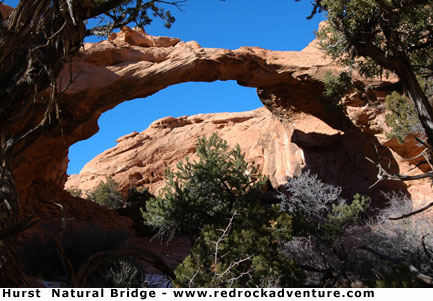
Hurst Bridge and the Vanishing Triple Arch
 Arches and natural bridges fascinate me – I seek them out when I’m exploring an area. Some are famous tourist attractions, like Rainbow Bridge and the multitude of arches in Arches National Park. But most of these gravity-defying enigmas are obscure, seldom visited, even though they are found in scenic areas offering great recreational opportunity.
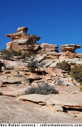
Dozens of bridges and arches can be found in the rugged San Rafael Swell, but most are relatively unknown.
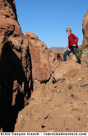
I did a fun little adventure hike over the weekend, trying to find a reputed triple natural bridge, but failed in that quest because of the rugged terrain and winter conditions. I did hike past Ernie Arch and under Hurst Bridge, and those two sights made the trip worthwhile.
The late January weather was very nice – blue sky and warm sunshine – but I underestimated the amount of snow and ice lingering in shady spots. Exclamation Bridge, described as one of the most spectacular sites in the San Rafael Swell, is well hidden in some of the most difficult terrain on earth. Viewing the steep, rugged route ahead, and realizing the sun was sinking toward the western horizon, I decided I’d have to continue my search in a few weeks, when the ice is gone and the days are longer.
 I’ve since found a report that suggests Exclamation is a double bridge, not a triple. That’s a bummer, if true. I have to verify that for myself because one of my long-term goals is to find a triple arch or natural bridge. I’ve tried, but every time I approach such a mystical structure it morphs into a mere double. For example, maps show a rock span named “Triple Arch” on Lake Powell near the mouth of the San Juan Arm. But the name is a misnomer. It is really a double arch that looks like a triple from a distance.
There is virtually no information available on Exclamation Bridge, other than the fact that it exists in a slot off Ernie Canyon in the San Rafael Reef north of Temple Mountain. The sketchy details I’ve uncovered suggest it is located in a maze of deep, narrow canyons. It was apparently discovered in 2004. I got close enough to view the surrounding chasms, and their ruggedness convinced me to wait for improved conditions. The narrowness and depth of these chasms, and the height of their numerous dry falls, compare to the darkest slots in Zion National Park. It’s fun country.
If you know of a genuine triple bridge or arch, please tell me about it. And, if you’ve seen Exclamation for yourself, I’d like to hear from you. I’ll probably try to reach it in mid-March. I almost always have room for another hiker or two, if you are interested.
 Hurst Bridge is well worth a hike, all by itself. It is very scenic, as you can see from my photo, and not far from the trailhead. It is difficult to find and the hike requires strenuous scrambling up steep ridges. To find the bridge you need a 7.5 minute topo map, good route finding skills, a GPS and enough time to wander through the canyon maze. It took us 4 hours to find it, and only 1 hour to hike out.
If you go into that area, carry water because there isn’t any in the drainage. And you’ll need a high-clearance 4X4 to get to the Ernie Canyon Trailhead.
So, where are the hiking instructions? I’m not going to give any. I’ll give the latitude and longitude of Hurst Bridge (N 38º 44’ 10”, W 110º 34’ 16”), but that’s all. With that, if you know what you are doing, you can study your map and plan a route.
If you don’t know what you’re doing then you have no business hiking in that country. It really is some of the roughest terrain on earth.
- Dave (dave@redrockadventure.com)
Subscribe to:
Posts (Atom)